IDL> read_eit, eitf, eindex, edata ;Read the data
IDL> eit_prep, eindex, data=edata, oeindex, oedata ; (optional) PREP the data (eit,trace,sxt)
IDL> index2map, oeindex, sdata, eitmap ; make a map
IDL> plot_map, eitmap, grid=15, xsize=1024 ; plot the map with a solar grid
IDL> oplot_nar, anytim(oeindex, /ecs) ; overplot NOAA Active Region info
IDL> index2map, oeindex, sdata, subeitmap, /sub ; define/generate a sub region map
You will be graphically prompted to select a sub region
Use the left mouse button to move the box, the center
button to resize and the right button to select/quit
For this demo, select AR 8227
IDL> rd_mdi, mdif, mindex, mdata ; read mdi index,data
IDL> index2map, mindex, mdata, mdimap, ref_sub=subeitmap ; make the corresponding mdi map using eit sub reqion map as reference (index2map calls sub_map internally
IDL>
plot_map, mdimap,/over,/rotate,/positive,lcolor=!p.color,
drange=[-500,500]
; overplot rotated postitive polarity
IDL>
plot_map, mdimap,/over,/rotate,/negative,lcolor=0,drange=[-500,500]
; overplot contours for rotated negative polarity
IDL> oplot_nar,anytim(oeindex,/ecs) ; overplot NOAA Active Region info
IDL> plot_map,eitmap,grid=10,center=[-900,300],fov=10 ; zoom in on NorthEast limb
IDL> efiles=eit_files('25-may-1998','8-jun-1998',wave=171,/full)
IDL> ss=grid_data(file2time(efiles),hour=24)
IDL> read_eit,efiles(ss),eindex, edata
IDL> eit_prep, eindex, data=edata, outindex, outdata
IDL> sdata=sobel_scale(outindex, outdata, minper=5,hi=2000)
IDL> xstepper, sdata, anytim(outindex,/ccsds)
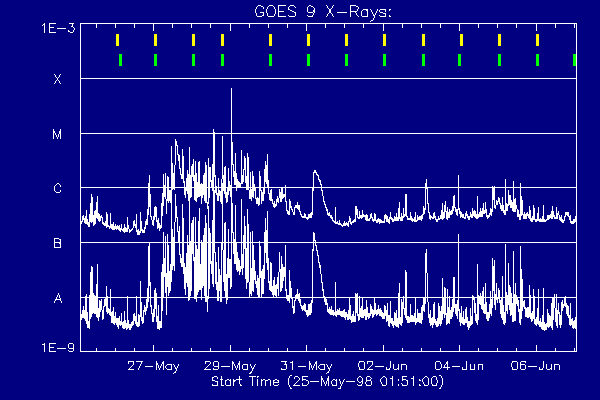
Plot GOES light curve for the period - annotate with EIT and closest
MDI image times. Note dbase input is in the form of EIT index records
IDL> wdef,xx,600,400,/ur ; [,/zbuffer]
IDL> linecolors
IDL> time_window, eindex, t0, t1
IDL> plot_goes,t0,t1,/one_minute,background=11
IDL> evt_grid, eindex, tickpos=.9, color=5,thick=2
Find and read MDI images closest in time to the above EIT images.
IDL> mdifiles=mdi_files(eindex,ftimes=ftimes)
IDL> rd_mdi, mdifiles, mindex
IDL> evt_grid, mindex, tickpos=.85, color=7,thick=2
|