These notes show what is required to access CDS data, calibrate it and begin to analyse the data arrays.
For a detailed discussion on many data-related topics, CDS Software Notes are available, and within IDL there are online routines which provide help on finding and using the individual software routines.
If you are interested in keeping up with what's new with CDS data and sharing problems/solutions you should sign up to the CDS email list .
1) Requesting and designing CDS observations
(Index)
The initial request. (Index)
Discuss your requirements with the CDS Principal Investigator or his deputy as far in advance as possible. Once your observations have been approved in principle you will be asked to submit a detailed design proposal. If you have access to the planning software you may perform the detailed observation design yourself, otherwise it is done in consultation with the project staff at RAL.
Details of what CDS has planned for the next few weeks/months can be seen in the on-line Request Diary.
The detailed design. (Index)
CDS already has observations designed to cover most requests, but if you really need to design something new then the IDL tools mk_raster and mk_study can be used. You will need to download some of the operations software for these routines to work.
The process of designing a CDS observation starts with the instrument setup. For either spectrometer
this involves deciding on:
a) the slit to be used - there are several
options.
b) the raster area (this can be adjusted in
various ways).
c) the exposure time for each spectrum.
This depends on the source target and it's best to
look at existing data to judge this.
Usually the limiting factor is the total duration of the resulting
raster and, for NIS, the contamination by cosmic rays.
d) the line selection list for NIS
(for GIS all the spectrum, apart from channel #2, is downloaded). This
selection should be based upon the scientific goal.
For NIS a maximum of 20 lines may be chosen. Often
though this has to be curtailed to restrict the amount of
telemetry needed.
e) the size of the data windows around each selected wavelength.
Some leeway is available depending
on the analysis requirements, but examine existing data and be aware of the effects of the
extended line profile wings
and NIS2 asymmetry in the ability to determine background levels and fit profiles.
f) the compression scheme.
It is also possible to ameliorate the telemetry situation for NIS data
by compressing the
data before transmission. The standard option is to pack the 12 bit data into 16 bit words, but
other options are available.
Once preliminary choices of these parameters have been made, the routine mk_raster should be used to check out the consequences in terms of the overall duration of the raster. CDS has an on board store of approximately 150 Kb for data coming from the detectors. If this is filled during a raster then the on board timing becomes limited by the rate at which telemetry can empty that buffer (~1.5 Kb/sec). Depending on the amount of data read per exposure this can then lead to a sudden change in the inter-exposure time within a raster.
If you encounter problems with planning new observations, email the CDS staff at RAL.
The first hurdle is to identify and retrieve the data files you wish to analyse.
If you know the file names, the data can be requested from CDS
staff at RAL.
If you only wish to look at data use the CDS web atlas (follow the ATLAS link within the CDS
home page or use the CDS
search engine
to select and display sets of data.
If you know the selection criteria (eg instrument, date/time, program name etc.) you can
select and download data from the
SOHO archives
either at RAL or in the USA.
If you are at a site that has copies of all the CDS catalogue databases (and their
location is defined by the environment variable ZDBASE ),
datasets can also be identified using the command
On the assumption that you wish to work at a lower or programmable level, the data
file (using s12345r00 as an example) can be read with the command
2) Finding and reading the data
(Index)
If any of the data files you identify in xcat are available
locally in a directory defined as
CDS_FITS_DATA , it is also possible
to read and display the data within xcat .
This loads the data into a so-called
quicklook data structure
(QLDS) - any name of course can be used for the variable.
Once the data have been loaded, a quick look at it and some analysis can be done within various packages provided in the CDS software. The QuickLook package itself (the same as is available from xcat ) is run with the command
3) Cleaning and calibrating the data
(Index)
NIS data should be cleaned to eradicate the worst effects of cosmic rays hits. For example:
CDS software Note 46: Missing Pixels and Cosmic Rays (PostScript - 244 Kb)
For most purposes the cleaned data need to be calibrated, both in the sense of removing unwanted instrumental characteristics and in the sense of converting the detected signal to physical units.
The former is achieved with the commands:
Note that in practice cds_new_spike will have run vds_debias on the data itself, and furthermore so too will vds_calib if it hasn't previously been applied to the data - all in all the call to vds_debias is redundant!
To convert the data to physical units use:
are required to clean and calibrate a suitable dataset.
4) Analysis of the data
(Index)
Once the data are cleaned and calibrated they can be extracted from the QLDS for further analysis. There are many routines for extracting data and information from the data structure, many of which are described in CDS Software Note 41. (PostScript - 292 Kb)
 What spectral lines and data windows were used in the observation?
(Index)
What spectral lines and data windows were used in the observation?
(Index)
The /SHORT keyword ensures you only get a summary of the data for example
Window        Label         Band    Xmin   Xmax    Wmin      Wmax
  0       HE_1_584_33       NIS2    601    618    583.25    585.24
  1       FE_16_360_76      NIS1    750    767    360.17    361.37
  2       MG_9_368_06       NIS1    854    871    367.50    368.70
  3       O_5_629_73        NIS2    989   1006    628.81    630.81
The Xmin Xmax numbers give the detector start and stop pixels for each data window. The wavelengths are calculated using an average pixel-wavelength conversion applicable to the date of observation. The table above also shows that the data windows are 18 pixels wide.
To obtain a wavelength array applicable to a particular data window (eg HeI) use the pix2wave function.
The routine gt_spectrum can also be used to extract a spectrum and related wavelength arrray.
How do I extract a particular data window?
(Index)
where N is the window index (0 to 3 in the example above). The variable data will then be a data array with from 2 to 4 dimensions. The dimensions are always in the order (Wavelength , SolarX, SolarY, Time). The fourth dimension (Time) is only added where the observation sits at the same SolarX location and takes repeated exposures. In that case the SolarX dimension is retained, but only has one element.
Typically:
will give an array something like
DATA FLOAT = Array[18, 120, 143]
indicating that the wavelength dimension has 18 pixels, 143 pixels (the maximum) were selected along the slit (SolarY) and 120 exposures were taken by stepping in SolarX.
How can I create a simple image from the spectral data?
(Index)
The simplest ways are to average over the spectral dimension:
or, using the QLDS rather than the extracted data array, choose a specific wavelength range (w1 to w2) over which to integrate
The resultant image can be displayed:
The last command may not give the expected display because of the presence of missing data.
How do I retrieve a sample spectrum?
(Index)
You may wish to plot the spectrum obtained in a single exposure and at a single location along the slit.
or equivalently if the data array has already been extracted from the data structure
where the wave array was defined earlier.
Various gt_xxxx routines may be packaged to define the average spectrum over a given spatial area, but if the area is simply rectangular then for instance
will do.
5) CDS Frequently Asked Questions
(Index)
Data and software
Instrument performance
Data features
Miscellaneous
What software installation do I need?
(Index)
We recommend the SolarSoft installation This gives access not only to CDS software but software from other instruments on SOHO and from other solar missions.
How do I know what data files exist, and which ones can I use?
(Index)
CDS maintains a catalogue and atlas of all its observations. Check out our data rights policy and see the section Finding and reading the data on this page for details of how to search for and retrieve data.
The CDS ATLAS of observations is available from here.
How do I know what software exists
(Index)
A variety of on-line help is available within IDL. CDS Software Notes are available, many of which deal with data analysis.
What is the format of the data files?
(Index)
The data from each CDS raster are stored in a
FITS file as a binary table.
How accurate is the intensity calibration
From a comparison with Sumer data a figure of 30-40% is suggested
for the absolute calibration. A summary of the history and current position
of the calibration can be
found here.
The calibration is under continuous development.
How accurate is the wavelength calibrationAlthough nominally CDS has a fixed wavelength range, small changes in the zero point of the pixel-wavelength relation can occur, primarily from on board temperature changes caused by varying illumination of the structure by the Sun. The wavelength array returned by the gt_xxxx functions or the pix2wave function is only an average determined from sample spectra. For accurate wavelength analyses, the zero point should be determined from each spectrum individually.
The calibration appropriate to a particular dataset is loaded when the data file is read. If you want to know what the currently loaded coefficients are, use the routine
A demonstration of how the wavelength zero-point varied before the optical bench temperature was stabilised can be seen here .
Note that small changes in the zero-point still occur (even during a raster) and so without careful
analysis no reliance should be placed upon absolute or relative velocity changes of less than 10-15 km/s.
How accurate is the pointing information?CDS uses its offset pointing system (OPS) to move to any location within range. This pointing has an rms of 5"-10".
When a dataset is read in using readcdsfits the pointing values in the QLDS are updated according to current knowledge of the spacecraft pointing - see Software Note #48 ( PostScript 87 Kb )
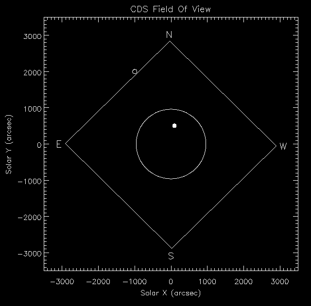
The extent of the CDS pointing capability (its Field Of View - FOV) can be seen using
where x and y can be arrays of Solar (X,Y) locations (arcsecs from disk centre) to plot on the diagram.
produces
this plot showing that the latter is an invalid
location for CDS.
Which line fitting routines exist?
From launch to the loss in June 98, the CDS/NIS line profiles were
very closely approximated by Gaussians. A number of routines allow fitting
of these profiles. See the options in the QL software, the cfit package
described in Software note #47 (
PostScript 6.6 Mb
)
and the low-level routine cds_gauss. After recovery
the NIS line profiles had changed. See Software note #53 (
PostScript 132 Kb
) for details.
What atomic data are available for
comparison with observations?
33: The CHIANTI Synthetic Spectrum Program
(PostScript 85 Kb)
37: Density and temperature diagnostic line ratios using CHIANTI
(PostScript 68 Kb)
50: DEM analysis using CHIANTI
(PostScript 296 Kb)
52: Routines for use with the CHIANTI database
(PostScript 336 Kb)
The Atomic Data and Analysis Structure ( ADAS ) is an interconnected set of computer codes and data collections for modelling the radiating properties of ions and atoms in plasmas and for assisting in the analysis and interpretation of spectral measurements and has also been used in connection with CDS data, particularly in the production of the NIS linelist .
What effects should I look out for in NIS data?
(Index)
As with any instrument/detector system there are a few features of the data produced that must be corrected for, or taken account of, in the data analysis. All of the features of NIS data currently known can be corrected for in the software, but users should be aware of their presence to avoid drawing erroneous conclusions or over-interpeting the data. The most obvious features of the NIS spectral data are
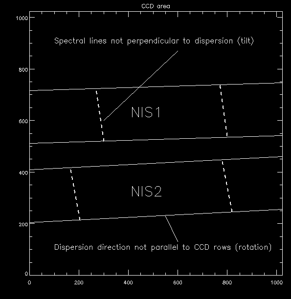
1) Spectrum ROTATION and TILT (Index)
Both of these features are illustrated in this diagram.
If these features are not corrected they will have the following effects upon the results:
The routine nis_rotate corrects for these effects. Note also that when data extraction windows are used in the design of a raster, their Y-pixel location on the CCD is automatically calculated to take account of the rotation. Consequently each data window array should have the same Y-pixel/SolarY correspondence. However if the windows are very wide some correction for rotation may still be necessary.
2) Wavelength change with scan mirror position (Index)
As the scan mirror rotates to provide the internal East/West spatial coverage it also introduces a small non-linear change in the wavelength scale zeropoint. The effect can be corrected for by again using the routine nis_rotate.
If you want to check what the correction values are as a function of mirror location say, for example, for NIS2 data taken in early 1996, try:
The sensitivity of the NIS CCD varies from pixel to pixel by a few percent. In order to eliminate this effect the routine vds_calib divides each exposure by a flatfield array which was determined in the laboratory before launch. Because of a slight shift of the alignment during launch, the laboratory flatfield array had to be modified after launch and while it does a pretty good job, some small residual inaccuracies persist.
In flight it is possible to take data which can approximate a uniform exposure of the detector by moving the OPS while the camera is exposing with the wide (90"x240") slit. A useful signal is of course only detected in the spectral position of the brighter lines. An example of this and of how such in-flight flatfields can be used if necessary for very accurate flatfielding is shown in this display .
The detector for NIS consists of a micro-channel plate (MCP) intensified CCD. The MCP suffers from degradation when exposed to radiation such that its sensitivity declines exponentially with photons detected (or, almost equivalently, with time).
Since the CDS spectral format is fixed, the emission lines fall more or less on the same area of the MCP all the time and the brightest lines affect the MCP the most, resulting in BURN-IN , which is a region of reduced sensitivity on the detector.
Special observations are taken to try and track the progress of the burn-in and the variation of sensitivity with MCP/CCD location and time is recorded in a database and a suitable correction applied in the routine vds_calib.
After the SOHO recovery the location of the NIS spectra on the MCP had changed and so a
new burn-in correction was established and is being monitored. Details are given in
CDS software note 51
The VDS Burn-in calibration
(PostScript 7 Mb)
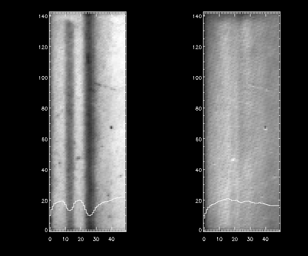
This plot shows a recent (July 2000) 'flat-field' exposure at the wavelength of HeI 584 Å. On the left is the raw data, showing the pre-loss and the current (to the right) burn in of that line. The profile of the image is overlayed - notice that the post-recovery burn in is already larger (at about 50%) than pre-loss. The image on the right shows the same data after the standard corrections have been applied.
5) Other fixed pattern effects (Index)
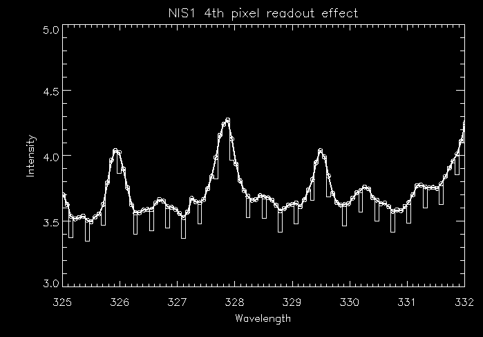
The NIS1 readout electronics create a low-level fixed-pattern effect in the spectrum. Every fourth pixel appears to have a lower count than expected. The effect is illustrated in this diagram. The effect is also corrected for in the routine vds_calib.
Note also the first and last two columns of CCD data should not be used in analysis. This only becomes relevant when the full spectrum is extracted or data windows cover the extreme columns of the CCD (as possibly in the OV 629A line in post-recovery data).
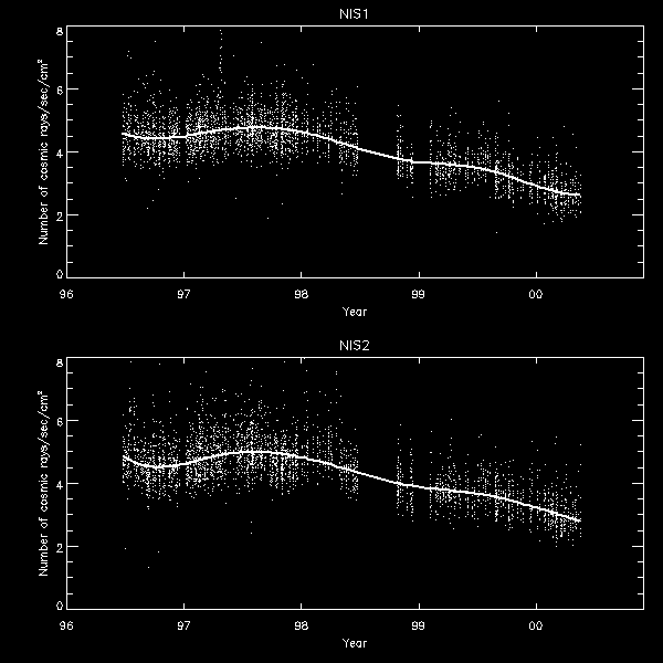
While the NIS is exposing, particles hit the CCD and release electrons which are then counted as signal when the CCD is read out.
A recent paper (PostScript 284 Kb) gives details of the longterm detection of cosmic rays by the CDS CCDs. The main figure shows that the count had declined by approximately 45% since launch owing to the increased strength of the heliospheric magnetic field at solar maximum. During that time 1-2% of pixels on the CCD are affected by cosmic rays in a 100 second exposure.
It is advantageous, before proceeding with any analysis, to identify which pixels are affected and to either mark them as missing data or to replace them with interpolated values.
Several routines are available to perform this process. They are described in
CDS Software Note 46
Missing pixels and cosmic rays
(PostScript 244 Kb)
Note that the routine cds_new_spike has beed added since that software note was written.
The NIS CCD readout electronics adds a constant value to the readout data to make sure the data values are well clear of any low-level effects. This is known as the BIAS level, and this value must be subtracted from the data value before any further (multiplicative) operations are applied to calibrate the data.
The bias level can change slightly as the characteristics of the electronic components vary. The level is therefore monitored on each exposure by reading out four small areas (10 x 10 pixels) of the unilluminated CCD. The subtraction is performed by the routine vds_debias and in a raster is subtracted on an exposure-by-exposure basis. Since there is noise on this value, this can cause apparent variations if very low signal levels are being compared from exposure to exposure or from raster to raster.
The bias level has been known to vary abruptly in the past, but since recovery seems to have been very stable .
If rasters are designed without the inclusion of the bias windows (a user option) then a suitable bias value must be supplied manually to the vds_debias routine.
The bias levels recorded within a raster's exposures can be plotted:
After de-biasing the spectra, there will usually remain a non-zero
continuum. This is largely scattered light coming from
outside of
the NIS wavebands. The main contributors are probably the Lyman-alpha 1216 Å
line, the Lyman continuum, He II 304 Å and perhaps strong coronal lines such
as Fe IX 171 Å. The scattering arises from the grating in the spectrograph.
Note also that the scattering has a strong spatial variation along the slit and is dependent upon the solar features under the slit. One consequence of this is that if the intensity data are simply averaged or summed over the line window, without any attempt at background or continuum subtraction, the resulting image may show faint spatial features which are not at all related to the line in question.
9) NIS data (noise) statistics (Index)
Since the NIS detector is not a photon-counting system, the data statistics cannot be derived from the raw data numbers alone. However, it is possible to derive the correct counting statistics and this is explained in
CDS Software Note #49 Deriving Statistics from NIS data (PostScript 174 Kb) .
10) Spatial offset between NIS1 and NIS2 (and GIS) (Index)
Both NIS1 and NIS2 use the same entrance slit to the spectrograph. However, there appears to be a N/S offset, sometimes amounting to several arcseconds, between the solar features that NIS1 sees and those that NIS2 sees.
A more detailed discussion is available.
If you want to see what the 'official' value of the offset is for any particular observation (it's a function of date and CDS (X,Y) location), try:
where x and y are the offset of NIS1 relative to NIS2 in arcseconds.
Note that the routine nis_rotate has been modified to include a call to gt_nis_alignment if the /ALIGN keyword is set.
Note: There is also an offset between the imaging of NIS and GIS. GIS images appear approximately 13" south of their NIS equivalents. Specific (X,Y) pointings for GIS should therefore be 13" south of the values determined by the software (image_tool for instance).
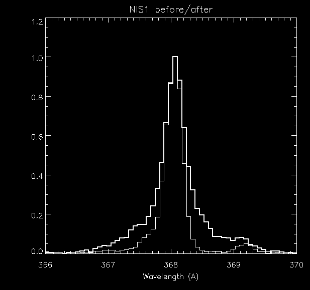
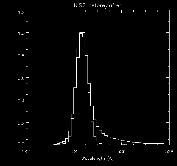
11) Changed line profiles after recovery of SOHO (Index)
The bakeout that CDS suffered during the SOHO loss changed the line profiles produced by the NIS spectrometer. The NIS1 profiles exhibit broader wings and the NIS2 profiles show a broadened and asymmetrical long wavelength wing.
The new profiles were characterised, and the fitting software modified to cater for them, as described in CDS Software Note #53 ( PostScript 132 Kb ).
What are the features of GIS data?The GIS has four SPAN detectors positioned around the Rowland circle of the grating. Currently detector #2 (the one covering the HeII 304 Å line) is not operational.
Each detector provides a 2048 pixel one-dimensional spectrum with complementary wavelength ranges . Since the GIS optics are astigmatic a small slit (2"x2" or 4"4") must be used and rasters are built up by scanning both the internal mirror (E-W) and the slit (N-S).
The setup of the detector is dependant upon the feature to be observed. Loading a new setup requires approximately 20 minutes of on board CPU time so it is unwise to plan observations that require frequent switching between different sources. Contact the GIS team for advice if you are planning some GIS observations.
Detailed information on handling GIS data can be found in the following CDS Software Notes:
54: CDS-GIS Instrument Guide
(PostScript 3 Mb)
55: GIS Software User Manual
(PostScript 465 Kb)
56: GIS Calibration Details
(PostScript 1 Mb)
How do I compare CDS images with other SOHO data?It is possible to make maps from CDS data which have the pointing information associated with them and then to compare those with data from other instruments. The package of programs is described at Dominic Zarro's web site.
A quick example of how to create a map object from CDS data.
Is there an official CDS line list?Brooks et al. have compiled a quiet Sun line list for NIS and it is available here.
There is also a line list created from the CHIANTI database.
Some spectra from previous solar missions that may be useful for identifying lines in NIS spectra are:
What is the spatial coverage and resolution of CDS?The internal scan mirror and slit movement of CDS allow CDS rasters to cover a maximum area of 4' square within a single raster. The E-W coverage is created by the scan mirror which can move in steps of 2.03" (normally assumed to be 2"). Movement can only be in one direction from West to East.
In NIS the N-S coverage is usually provided by the long slit (normal slits are 2"x240" or 4"x240"). For GIS the N-S dimension is scanned by moving one of the small square slits which can move in steps of 1.01" (normally assumed to be 1"!).
The whole CDS instrument can be pointed anywhere on the solar disk by use of the Offset Pointing System (OPS). The area reachable can extend out to a maximum 1.4 solar radii in certain directions. See the procedure cdsfov for details.
The paper
 Intercalibration of SUMER and CDS on SOHO. I. SUMER
        Detector A and CDS NIS.
        Pauluhn, A., Ruedi, I., Solanki, S., Lang, J., Pike, C.D.,
        Schuele, U., Thompson, W.T. and Huber, M.C.E.
        1999, Applied Optics 38, 7035.
derive the
Point Spread Function (PSF) for CDS/NIS from a comparison
with Sumer data. They suggest

where J is the first-order Bessel function and the parameter b has a value of 0.31 giving a slightly elliptical form with FWHM(x) = 6" and FWHM(y) = 8". Their data were taken with the 4" wide slit and it is possible that a slightly better spatial resolution (in SolarX) is achievable in pre-loss data which used the 2" slit.
A discussion of the post-recovery PSF is also available.
What is the spectral coverage and resolution of CDS?
Information on the spectral coverage and resolution of NIS is given
here .
After the SOHO recovery the NIS line profiles changed, exhibiting extended wings and an
asymmetry in the NIS2 profiles. The software was modified to permit fitting of these
new profiles and is described in CDS Software Note 53:
Post-recovery broadened line profiles
(PostScript 128 Kb)
The PSF of the spectrograph (as opposed to the telescope) optics affects the line profiles and can, if asymmetric, affect the interpretation of velocity information. This is discussed in a paper by S. V. H. Haugan
where it is predicted that the NIS spectrograph PSF must be slightly elliptical and rotated. From NIS observations taken with the small 2"x2" slit, this indeed appears to be the case.
See the routine CDS_CORR_GRADIENT for a possible correction technique.
Information on the spectral coverage and resolution of GIS is given here . The temporary loss of SOHO appears to have had little effect upon the spectral characteristics of GIS.
What information is available on scattered light in CDS?Some pre-flight information is available in
which gives results for measures at a wavelength of 68 Å.
For a scientific application and extension of this to CDS observed wavelengths see
Can CDS track solar features as the Sun rotates?Yes and no!
Please read software note #45 for details, but remember the "feature tracking" option cannot be relied on to give stable pointing at the 2" level. Remember also the difference between feature tracking and rotation compensation.
Where do I find further help?If you have further questions about CDS data please contact the project staff.
6) Tricks of the trade
(Index)
If you would like to advertise (and be given credit for) any tricks/titbits you've discovered about dealing with CDS data please let us know.
As a start, see these points that have been notified to us.
Watch out for
NIS second order lines
contributed by Enrico Landi.
Beware the
NIS FeXIII density diagnostic
contributed by Peter Gallagher and Ken Phillips.
Notes on
Deriving density, temperature and abundances
contributed by Peter Young.